‘This Beautiful Work of Art’
Skene and Slight's Continental Australia
One of the most beautiful geological maps ever produced in Australia was the map of Continental Australia… Geologically colored by Arthur Everett, published by the Mining Department of Victoria in 1887. It was printed in colours by the Lithographic Branch of the Mining Department on a base supplied by the Victorian Lands Department. It is this base map which is the subject of this essay.
Alexander John Skene (1820-1894) was appointed Surveyor-General for Victoria in September 1869. At that time most of the maps produced by the Victorian Lands Department were sale plans and parish plans. There was no adequate official map of the Colony of Victoria, merely an unsophisticated map at a scale of eight miles to an inch compiled in 1858 for the Census of Victoria carried out in March 1857. This map had been produced in haste but because it fulfilled a need for a medium-scale map of the Colony, it was updated and used for various purposes until the 1860s. One of Skene's innovations following his appointment as Surveyor-General was to begin a project to compile and publish accurate and sophisticated medium-scale maps of the Colony. Rather than have these maps drawn for lithography and then printed, he proposed having maps engraved and then printed by transfer lithography. This was usual procedure at that time to produce the best maps and for this purpose he recruited a skilled map engraver, William Slight (1828-1887).
Slight had worked for the Ordnance Survey of Great Britain at Southampton before he came to Melbourne in 1854, where he worked on his own account or with others. Much of his work was undertaken on contract for the Government, including engraving many of the maps of the Geological Survey of Victoria and the mining map of Victoria for the Mining Department, issued in 1866. He was appointed to the Lands Department in 1869 and given the task of engraving the series of maps which Skene had proposed. These included ‘8 miles = 1 inch’ and ‘16 miles = 1 inch’ maps of Victoria, a ‘16 miles = 1 inch’ map of south-eastern Australia, County plans and geodetic plans. On their publication the maps of Victoria were enthusiastically received.
1It is not known what prompted Skene to produce a map of the whole of Australia. Presumably the success of the engraved maps of Victoria played some part, but it is hard to believe that Victorian politicians would support a project that had little direct practical value to the Colony. Whatever the case, in February 1874 it was announced that Skene was engaged in preparation of a large-scale map of Australia at a scale of 40 miles to an inch, for which he was receiving assistance from the survey departments in other colonies.
2 There was a precedent for the Lands Department producing a map of Australia. A rather crude map entitled
General Map of Australia showing the routes of the explorers on a scale of 110 miles
32
to the inch was compiled by R.B. Smyth and published in 1859. Later editions with additional explorers’ routes were also published.
Skene's map was to show rivers, main roads, railways, telegraph lines and the routes of explorers. Mountains were only to be indicated by names in the first edition, but were to be shown by shading at a later time. The land was not to be fringed by ruled lines to show shoal water as was usual because there were too many names of rivers, headlands and ports. Instead the printed version would have the sea indicated by a blue tint.
3 By January 1878, the four sheets of the map had been engraved by Slight and the work of revision had been completed on three sheets, when he was summarily dismissed, along with over 200 other public servants, on 9 January (‘Black Wednesday’), when the Berry Government's Appropriation Bill was blocked by the Legislative Council.
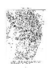
4 However, Slight was reinstated in April 1878 and work continued on the map. New additions to it were closed off on 14 June 1879, which date is engraved on the map. The State Library has a draftsman's fair copy of part of the map, which would have been used as a guide for the engraver [
Fig.15]. It is mounted on a huge piece of linen and has the meridian and parallels drawn in pencil, but only Tasmania and Queensland are ‘finished’ in ink. Portion of New South Wales is inked in, but there are no place names. There are a large number of place names inked in for Queensland but not all were included on the published editions of the map, presumably because their inclusion would have made the map too cluttered.
The sale price for the map was set as early as April 1879. The four sheets of the map cost £1/1/- unmounted, £2/2/- mounted on rollers and varnished, and 5/6 per separate sheet.
5 Long before the map was published, the bookseller and publisher, F.F. Bailliere, after consultation with R.P. Whitworth, offered to have an alphabetical index to the place names on the map with their latitudes and longitudes prepared, if the Government would purchase not less that 500 copies at 5/- each. Bailliere estimated there were about 20,000 names on the map and regarded it as ‘in every particular without doubt the finest chart of the “Australias” yet issued to the world’.
6 No action was taken on this offer, but R.P. Whitworth, who worked for Bailliere editing
Bailliere's Gazetteers, did make an index which was published in the
Australian Handbook issues for 1883,1884 and 1885.
The map as issued to the public was not printed directly from the copperplates, but was printed by taking transfers from them and printing from lithographic stones. This was a method used to save wear on the copperplates and to speed up the printing. The image was printed onto the gummed side of transfer paper using the copperplate. The paper was then placed image down on a clean lithographic stone, run through a lithographic press to transfer the printed image to the stone, and then the paper was wet from the back to dissolve the gum on the other side and the paper pulled off the stone, leaving the image behind. The stone was inked up and the map printed from the stone in a lithographic press. Other information or images could also be included on the printing stone that were not engraved on the copperplate. For instance, the population of each of the Australian colonies and also the latitudes and
33
34
longitudes of the capital cities. Two colour stones, one for the blue tint for the sea and one for burnt sienna for the land, were also made; and the paper with the black map image run through the press twice more to have the coloured tints applied. Each of the four sheets of the map was treated in the same way to produce the final product. The resulting map measured 5 feet 6 inches by 4 feet 7 inches. It was issued in October 1879 to critical acclaim, the
Argus reporting that:
… there must be awarded high praise indeed to the result of Mr A.J. Skene's labours in the present case, and to the engraver, Mr William Slight. It is entirely creditable to the Government department by which it has been produced and the colony may be proud to send it forth’.
7One politician — Mr D.M. Davies, Member for Grenville — was sufficiently impressed with the map even before it was issued to request that free copies be sent to all free libraries of the Colony, but the Minister of Lands stated that it was very expensive and it would not be possible to do this for some time. A similar request was made in November 1879 by Thomas Cooper, Member for Creswick, who received a similar answer. The matter was raised again during debate on the Customs Duties Bill in December, when Cooper was ridiculed for wanting to spend £6000 to supply the map to free libraries. Cooper pointed out that it would cost only £640 to send a map costing £4 to 167 libraries. The matter was raised again by Davies in June 1880, but the Minister for Lands would not agree, saying that it would involve expenditure of at least £200 which the department could not afford, but he thought that at some future time the map might be supplied by degrees.
8 This was never done, which had unfortunate consequences for the survival of copies of the map.
With permission from the Surveyor-General, the map was reproduced photolithographically on a reduced scale (75 miles = 1 inch) in London by F. Waller for issue with the twelfth volume of the Australian Handbook for 1881.
The map seems to have been such a success that Skene immediately proceeded with a revision, despite the fact that the government ministers had thought the map too expensive to give to the free libraries. The next edition is dated 1 October 1880. It was either this map or the first edition that was exhibited in November at the Melbourne International Exhibition, and the justification for producing a revision may well have been the forthcoming Exhibition.
9 The October 1880 edition was also reprinted in London, but this time at the same scale for issue with the
Australian Handbook for 1883. The State Library does not hold a copy of the original issue of the map, but a good copy of the
Handbook with the reprint edition is held in the Rare Books Collection. This edition of the map was stated to have been printed from five copper plates, an additional plate being used for the islands to the north of Australia.
The official agent for sale of maps to the public was H. Byron Moore, who ran the Exchange in Collins Street. He advertised the map at £2/2/- in sheets and at £3/3/- varnished and mounted on rollers. He gave the size of the map as 6 feet by 4 feet 9 inches.
10 35
Once the major task of engraving the copperplates from the original draftsman's fair drawing was completed, revisions and additions on the copperplates were fairly easy to do by additional engraving or reworking. There is evidence to suggest that the revisional work was continuous. For instance, the south-east sheet of the map was used as a base for a map showing rainfall for the year 1883, issued in August 1884.
11 This map showed the distribution of rainfall in blue shading across Tasmania, Victoria, eastern South Australia, New South Wales and southernmost Queensland. The base map includes information not shown on the map dated 1 October 1880. This same base map was also used for a map showing rainfall for the year 1885. A copy of the 1883 map was recently donated to the State Library.
In 1886, the Sydney printing firm John Sands issued an atlas of the Australian colonies, entitled The New Atlas of Australia, edited by Robert McLean. It was published in two editions: a complete atlas of all the mainland colonies in one cover and a series of five separate atlases, one for each of the mainland colonies. Included in each set of maps was a small-scale map of each of the colonies at a scale of 50 miles = 1 inch. This map was the relevant section of Continental Australia, reproduced by permission of the Surveyor-General of Victoria. Presumably Sands was supplied with appropriate transfers from the copperplates to enable the firm's lithographers to put separate maps of each of the colonies onto separate stones for printing. An examination of these maps in the atlas shows that the firm's lithographers also added some additional information, such as odd place names and railway lines, presumably to bring them up to the date of printing. The maps as printed in the atlas also have coloured tints printed over the base, showing the various counties of the respective colony. The map of Victoria included Tasmania.
In June 1885, it was announced that an edition of the map of
Continental Australia was to be issued for the Colonial and Indian Exhibition to be held in London in 1886.
12 The map was to include information up to June 1885.
13 It was issued in September 1886 and formed item one of the featured maps in the Department of Lands and Survey's entry in Class 16 of the Exhibition.
14 It was apparently issued about June or early July 1886. The
Argus reported that:
The long and honourable career of Mr A.J. Skene as surveyor-general of Victoria, has been most appropriately closed by the publication of this valuable record of the advance of the great colonies of Australia, while those who are competent to judge express the opinion that probably no other man out of Europe besides its engraver, Mr William Slight, would have produced this beautiful work of art. The keeping of it up to date, and in the production of other maps of similar character, a large field lies open to Mr Skene's successor, and Mr Black's eminence in his profession and known enthusiasm for geographical research will doubtless keep the credit of the colony in works of similar utility well to the fore.
15Alas, despite this high praise, no institution seems to have bothered to have kept a copy and I have not been able to trace any surviving example of this edition of the map.
36
William Slight died in February 1887, so any further engraving needing to be carried out was undertaken by his son James, who had been trained by his father.
The geological map
At the 1880–1881 Melbourne International Exhibition, the Mining Department exhibited
A Geological Sketch Map of the Continent of Australia
at a scale of 50 miles to an inch, compiled from all sources by Arthur Everett, Chief Draftsman.16 This must have been a map with geological colours applied by hand to the first or second edition of Skene and Slight's map. This same map or another newly hand-coloured version was exhibited at the International and Colonial Exhibition of Amsterdam in 1883.
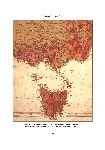
17 Eventually the Mining Department went ahead with a printed version of this map which was issued in November 1887. The 1886 edition of Skene and Slight's map, or a variant of it, formed the base for the geological map. Unlike the topographical map, the geological map was issued in six sheets, perhaps because the Mining Department, which printed the map, could not handle stones as large as those of the Lands Department on its presses. As it was, it needed 6 key (black) stones and 55 colour stones for the printing and must have taken a considerable time to print. It was printed in 11 colours and sold at a price of £3/10/-. The
Argus thought that ‘as a specimen of lithographic printing, the map is a creditable work of art, the registry or joining of the various colours being free from overlaps and uncoloured areas’. The Library has a copy of the geological map in which the six sheets are mounted on linen [
see Fig. 16].
18 As I stated at the beginning of this article, this is one of the most beautiful maps ever produced in Australia, but because of its size, very few copies have survived in collections.
Alexander Black (1827-1897) succeeded Skene as Surveyor-General on 1 July 1886 and the
Argus's confidence that the map would be kept up to date was not misplaced. The last edition of the map is dated May 1888 and bears Black's name. The face of the map has statistics of the Australian colonies dated December 1888, so presumably it was issued some time in 1889. I have found no newspaper report of its publication. It was probably done for the 1888–1889 Centennial International Exhibition held in Melbourne. Item 389, Class 15 included
Continental Map of Australia, Colony of Victoria and Contour Map of Melbourne, for which the Department was awarded a First Order of Merit and special mention for excellence. This exhibit received a Certificate equal to a Gold medal, because it was exhibited by a Government Department.
19 The Library has a copy of this map, which was varnished and mounted on rollers. A copy of this edition was sent to the Geographische Anstalt in Gotha, Germany, where it was reported as a first-rate map, having all the merits of the first edition, that is, clarity and clearness.
20No further editions of the map were produced, although James Slight was still working on the map in the latter half of 1889.
21 Probably the effects of the severe depression, which gripped the Victorian economy in the 1890s, spelled the end of it, and the copperplates eventually ended up in scrap.
Continental Australia remained the largest scale map of the country and was not superseded by equivalent maps until well into the twentieth century.
37
38
Unfortunately, most of the known copies of this magnificent map have survived only as roll maps that were varnished and mounted on rollers. Such maps are usually in poor condition, owing to the deterioration of the varnish used. For some reason, no copy seems to have been kept in the separate sheets as they were issued. This is surprising, given that there must have been many copies sold or given away to justify the map reaching four editions.
22Thomas A. Darragh