European Voyages of Discovery
Des Cowley
Australia Discovered in the Sixteenth Century?
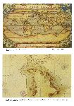
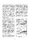
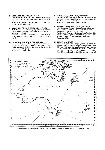
The argument for a Portuguese discovery of Australia in the sixteenth century rests, to a large extent, on the evidence of a series of French maps, produced in the middle of the sixteenth century, known as the Dieppe maps. The most important maps in the series are those by Nicolas Desliens (1541, 1566), Jean Rotz (1542), Nicolas Vallard (1547), Pierre Desceliers (1546, 1550, 1553) and the so-called Dauphin map (1536)
1, also thought to be by Desceliers. There is general agreement amongst scholars that the place names on these maps are of Portuguese origin, most probably derived from a common source such as a Portuguese world map.
Each of the Dieppe maps depicts a large landmass, Java La Grande, situated to the south of Java and separated by a narrow strait. The resemblance of this landmass to the Australian continent has led to an on-going controversy as to whether Portuguese navigators were responsible for charting the east coast of Australia well over two hundred years prior to Cook's first voyage.
Alexander Dalrymple is accredited with having made the first reference to one of the Dieppe maps in his pamphlet Memoir concerning the Chagos & adjacent islands (London, 1786), in which he implied that Cook had known of the existence of the map and used it in his charting of the east coast of Australia. He claimed, for instance, that the Coste de Herbiages (Coast of Vegetation) on the Dieppe map corresponded to Cook's Botany Bay.
Amongst nineteenth century writers, it was R.H. Major, Keeper of Maps in the British Museum between 1867 and 1880, who first championed the theory of Portuguese discovery in his publications Early voyages to Terra Australis, now called Australia (London, 1859) and The discovery of Australia by the Portuguese in 1601 (London 1861). But, in Australia, it was the resolute George Collingridge, an artist and self-taught historian, who did more than anyone else to lay the foundations of the Portuguese theory in his monumental work on early Australian cartography The discovery of Australia (Sydney, Hayes Brothers, 1895). Collingridge's work, although later attacked by Professor Arnold Wood and others, was to remain the single most important volume on the subject until the publication of Kenneth McIntyre's The secret discovery of Australia (Medindie, S.A., Souvenir Press, 1977).
In 1885 the Melbourne Public Library purchased an excellent set of hand coloured facsimiles of four of the Dieppe maps held by the British Museum — the Dauphin map, the Desceliers 1550 world map, and both Jean Rotz's Circular and Plane charts.
Beside the Dieppe maps, advocates look to the Mahogany Ship as the next best piece of evidence to support the theory of a Portuguese discovery of Australia. The wreck of this ship was sighted in the sandhills near Warrnambool on numerous occasions between 1836 and 1890 before being permanently covered by sand dunes. Early descriptions of the wreck have led to the theory that it may have been a Portuguese caravel. McIntyre further argues that the ship may have been a part of Cristovao de Mendonca's 1521 expedition which, he claims, as evidenced by correspondences between the Dieppe maps and the eastern coastline of Australia, charted the coast from Cape York Peninsula to Warrnambool before turning back, presumably due to the loss of a ship.
Recovery of the Mahogany Ship may yet see the history of Australia's early discovery and exploration rewritten. Extensive searching in the region of the original sightings has not, however, to this date, uncovered any remains of the wreck.
De QueirÓS and the Fifth Continent
In 1520 Magellan rounded the tip of South America and opened up the Pacific for the Spanish. The true extent of the world's oceans had at last been revealed. The restriction of Spain's trading routes to the equatorial latitudes, however, prevented any new discoveries being made in the southern oceans, and it was not until 1567 that the Spanish undertook a specific expedition, instigated by the viceroy of Peru, to discover the continent and lands believed to lie to the west of South America.
Mendana's 1567 expedition was responsible for the discovery of the Solomon Islands. A second expedition, again under Mendana, set out in 1595 from Peru in order to establish a settlement in the Solomon Islands. The expedition, however, failed to refind the Solomons and the settlement was made instead on the island of Santa Cruz. This settlement proved a complete failure and, subsequent to Mendana's death on the island, the remnants of the expedition, led by Pedro Fernandes de Queirós, sailed in November of the same year for the Philippines.
16
It was de Queirós who next set himself the task of discovering the southern continent. His expedition of 1605–1606 discovered a large landmass which de Queirós believed to be the South Land and which he named Austrialia del Espiritu Santo. In fact, de Queirós had discovered not the South Land but the largest of a group of islands later named by Cook the New Hebrides. It was during the exploration of Austrialia del Espiritu Santo that the ships of the expedition became separated and Luis Vas de Torres, continuing westward, made his celebrated passage through the straits that bear his name.
It was long held that Torres voyage between the southern coast of New Guinea and Cape York Peninsula remained unknown until Alexander Dalrymple brought to light the Arias Memorial in 1762. Cartographic evidence, however, suggests that the existence of the strait was generally known of in the seventeenth century, even though the problem of Torres Strait was not finalised once and for all until Cook's first voyage.
De Queirós himself made his way to Acapulco and from there to Madrid where he arrived in October 1607. Here he spent the last years of his life issuing memorials, some fifty in all, to the King of Spain describing his discoveries and urging for funds to continue his exploration of the southern continent. He was finally sent to Peru in 1615 but died at Panama during the voyage.
The memorials issued by de Queirós, ten of which have survived in printed form, are amongst the earliest published European material relating directly to Australia. An English edition of the eighth memorial, Terra Australis incognita, or A new southerne discouerie, containing a fifth part of the world. Lately found out by Ferdinand de Quir, was published in 1617.
Along with the death of de Queirós came the end of Spanish exploration in the Pacific. The Chilean lawyer Juan Luis Arias continued to petition for a mission to the southern lands until the 1630s but it was already too late. Spain's empire was over extended and the task of both exploiting and defending it was to take precedence over the search for new lands.
A Coastline Charted
With the decline in Portuguese and Spanish influence in the East Indies, the Dutch rapidly expanded into the region. The first Dutch fleet, commanded by Cornelis de Houtman, set sail in 1595 for the Spice Islands and shortly thereafter the Dutch East India Company was formed.
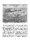
In 1605 the Duyfken, under the command of Willem Jansz, sailed from Bantam, a company trading post, to explore the southern coast of New Guinea. Jansz followed this coast to the east and, failing to sight the passage through Torres Strait, continued sailing down the west coast of Cape York Peninsula believing it to be part of the same landmass. Short of supplies, and having encountered hostility from the local aborigines, the Duyfken turned back after four months at sea at a cape named Keerveer (turn again). Without his having been aware of it, Jansz became the first recorded European to have sailed the coast of Australia.
Although the journal of the
Duyfken's voyage has not survived, there exists contemporary maps and writings which record its discoveries. Hessel Gerritz's 1622 map of the Pacific Ocean ‘Mar Del Sur. Mar Pacifico’ takes into account the voyage of the
Duyfken; while an anonymous 1670 map,
17
compiled from an original drawn on board the
Duyfken and subsequently reproduced in Weider's
Monumenta cartographica (The Hague, Martinus Nijhoff, 1925–1933) carries the legend: ‘This map shows the route taken by the pinnace
Duifien on the outward as well as on the return voyage when she visited the countries east of Banda up to New Guinea’
2.
The Dutch route to the East Indies, at the time of the Duykfen's voyage, followed a similar one to the Portuguese before them — either along the African coast through the Mozambique Channel or along the eastern coast of Madagascar. By 1615, however, it was being recommended to Dutch captains that they sail east after rounding the Cape of Good Hope as far as the longitude of the Sunda Straits before navigating north for Batavia. The official adoption of what became known as Brouwer's route, which directed ships toward the undiscovered coastline of western Australia, virtually ensured Dutch contact with its shores.
In 1616 Dirk Hartog, following Brouwer's route aboard the Eendracht, sailed too far east before turning north and came upon the west coast of Australia. This region of coastline subsequently appeared on Dutch maps as ‘Landt van de Eendracht’. Although the log of the voyage has been lost, evidence confirming Hartog's discoveries survives in the form of a pewter plate, inscribed with details of his landing, which was found on an island (since named Hartog's Island) by Willem de Vlamingh in 1697. Vlamingh removed Hartog's plate and replaced it with another inscribed both with the original message as well as with a record of his own visit. Vlamingh's plate is now held by the Fremantle Museum while Hartog's plate is in the Rijksmuseum in Amsterdam. The journal of Vlamingh's voyage, which spent several months exploring the west Australian coastline, was published in Amsterdam in 1701.
Dutch ships, after 1616, made further landfalls on the west coast as they continued to follow Brouwer's route. Between 1618 and 1622 the Zeewolf, Mauritius, Durdrecht, Amsterdam, and Leeuwin all made sightings of the west Australian coastline.
In 1627 the Golden Zeepaerdt, commanded by Frans Thyseen with Pieter Nuyts, a high-ranking Company official, on board, became the first Dutch ship to sail the south coast of Australia. Little is known of the voyage; however, Hessel Gerritz's map of 1628 (mistakenly dated 1618) charts some thousand miles of southern coastline, almost to the end of the Great Australian Bight, to a small group of islands named Nuyts Archipelago. The map carries the inscription: ‘Landt van P. Nuyts, discovered by the Golden Zeepaerdt of Middleburgh, 26 Jan., 1627’.
An earlier Dutch voyage, which failed to sight the Australian coastline, was that undertaken by Le Maire and Schouten in 1615–1616. Inspired by the accounts of de Queir⊘s, they set off around Cape Horn, although not before discovering a passage between Tierra del Fuego and a land which they named Staten Land. This latter they believed to be part of Terra Australis and it was not until 1643 that Hendrik Brouwer proved it to be an island. The expedition then sailed across the Pacific in search of the southern continent. Had the arguments of Le Maire, who endeavoured to maintain a westerly course, prevailed, the Dutch may have reached the east coast of Australia 150 years prior to Cook. After having sailed sixteen hundred miles across the Pacific without sighting Terra Australis, however, Schouten declared the plan unsafe and steered instead a course for the north coast of New Guinea, which they then charted for the first time in detail.
Accounts of the voyage of Le Maire and Schouten, published in Amsterdam as early as 1618, were greeted with great excitement. The expedition, however, proved to be the last of the seventeenth century to search for the South Land from the east.
The voyage of the Pera and Arnhem, commanded by Jan Carstensz in 1623, further charted the coastline first discovered by the Duyfken. Again the Dutch failed to discover Torres Strait, and the ships sailed down the west coast of Cape York Peninsula as far as latitude 17°S, before turning back at a point named Staten River. On the return voyage, the two ships became separated and the Arnhem came upon the east coast of what is now Arnhem Land.
Castensz's journal of the voyage kept on board the Pera, Twee togten naar de Golf van Carpentaria 1623 (Amsterdam), was first published in 1859. The journal of the Arnhem's voyage has been lost and its discoveries, recorded in a copy, made in about 1670, of the ship's original chart, were not incorporated into Dutch maps prior to Tasman's voyages.
In June 1629 the Dutch ship
Batavia was wrecked on the Houtman Abrolhos, a group of dangerous shoals lying off the west Australian coastline. After ferrying the majority of the ship's company to several nearby islands, Francois Pelsaert, commander of the
Batavia, set off for Batavia in one of the ship's boats. In his absence, Jerome Cornelis, the ship's supercargo, led a revolt which resulted in the massacre of some 125 men, women and children. On Pelseart's return, the rebels were captured
18
and five of the seven ringleaders, including Cornelis, were tried and hanged on the spot. The remainder were taken back to Batavia for trial.
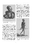
Pelsert's account of the incident, entitled Ongiluckige voyagie, van't schip Batavia (Amsterdam, 1647) contains important early descriptions of the Australian coastline, including the first published reference to the kangaroo. The text is accompanied by six woodcuts which graphically illustrate scenes of the massacre and the subsequent torture and execution of Cornelis and his men.
In 1636 the new Governor General of Batavia, Anthonie Van Diemen, sent two ships, commanded by Gerrit Thomasz Pool, to explore the coastline which lay between those discoveries made by the Pera and Arnhem around the Gulf of Carpentaria and Arnhem Land, and those discoveries made on the west coast. It was not known, for instance, whether the gulf extended south into a large sea towards Nuyt's Land; whether Arnhem Land was an island; or whether the coast of Arnhem Land extended south west toward the Houtman Albrolhos. The expedition, however, was a failure. Pool and three of his men were killed by natives during a landing on the coast of New Guinea. The two ships, under the command of supercargo Pieter Pietersz, ran into weather difficulties and, after making no more than a superficial investigation of Melville Island and Arnhem Land, returned to Banda.
Van Diemen next dispatched in August 1642 two vessels, the
Heemskerck and
Zeehan, under the command of Abel Tasman. Following a plan devised by Francois Visscher, Tasman proceeded south from Mauritius and then east below the landmass known as Nuyt's Archipelago. On 24 November the
Zeehan sighted land which they named Anthonie Van Diemen's Land. After charting the southern portion of the Tasmanian coastline, the ships headed east and on 13 December sighted
19
the southern island of New Zealand, which they named Staten Land. Next, after having charted the western coastline of New Zealand to the northernmost point of the North island, Tasman struck out for the Solomon Islands, which he failed to find. The ships then returned to Batavia, arriving on 15 June 1643.
Tasman's first voyage was responsible for the discovery of Tasmania and New Zealand; furthermore, by sailing beneath the Australian coastline he proved that New Holland was not connected to the Great South Land, although he did believe the western coastline of New Zealand to be part of the unknown South Land.
Tasman's second voyage of 1644 provided answers to the questions (except for the passage through Torres Strait) that Pool's 1636 expedition had failed to resolve. Commanding the yachts Limmen and Zeemeeuw, and the galliot Bracq, Tasman followed the Australian coastline west from Cape York Peninsula, round the Gulf of Carpentaria and Arnhem Land, to 23° southern latitude on the west Australian coastline, almost to Willem's river, before turning back to Batavia.
Although the results of Tasman's voyages appeared on contemporary maps, such as Joan Blaeu's 1648 map Nova Totius Terrarum Orbus Tabula, within a relatively short period of time, it took over a quarter of a century of the first report of Tasman's discoveries to appear in print. The first account of the 1642–43 voyage appeared in De Nieuwe en Onbedende Weereld (Amsterdam, 1671), compiled by Arnoldus Montanus. English readers learned of Tasman's voyages via Robert Hookes Phylosophical translations and collections (London, 1682) and John Narborough's An account of several late voyages and discoveries (London, 1694). The journal of Tasman's 1642–1643 voyage, which was discovered in Batavia in 1854, was first published in Amsterdam in 1898 in facsimile reproduction with an English translation.
After the death of Van Diemen in 1645, the period of Dutch discovery came to a close. Dutch ships continued to make landfalls on the Australian coast but, outside of Vlamingh's 1696 expedition, which was actually planned, and Roggeveen's strange mission to find the South Land in 1721, which resulted in the discovery of Easter Island, the Dutch played no further part in the exploration of the Australian coastline.
New Voyages of Dampier
The first English navigator to arrive on Australian shores was William Dampier, who landed in January 1688 at King's Sound in north west Australia aboard the Cygnet. During his brief stay, Dampier made detailed observations of the country and its inhabitants and, on his return to England, published A new voyage round the world (London, 1697), which immediately became a bestseller. The popularity of Dampier's work is evidenced by the fact that a second edition was published in the same year, a third edition in 1698, and a fourth in 1699.
Dampier set off on a second voyage in January 1699 in the H.M.S. Roebuck, sailing around the Cape of Good Hope and arriving at the western coastline of New Holland in July 1699. He followed the coastline north to Shark Bay and from there on to Dampier Archipelago. After a brief landing in the vicinity of Roebuck Bay, Dampier departed New Holland in September for the north coast of New Guinea, where he discovered a large island, New Britain, later shown by Carteret to be two islands.
With enough material for another epic travelogue he turned his vessel for home. He passed the Cape of Good Hope but was wrecked on Ascension Island
20
in February 1700. After surviving for six weeks on a diet of turtles and goats, Dampier and his men were rescued by a passing English squadron and taken back to England.
Dampier followed his A new voyage round the world with Voyages and descriptions (London, 1699); a second edition appearing in 1700 and a third in 1705. A voyage to New Holland, &c. In the year 1699 (London, 1703) appears to have been less successful, the first edition not being followed by a second until 1709.
Dampier's third voyage in 1703, aboard the St. George, was accompanied also by the Cinque Ports, commanded by Alexander Selkirk. It was on this voyage that Selkirk was left marooned on the Juan Fernandez Island, off the South American coast. Dampier was pilot aboard Captain Woodes Rogers privateer, the Duke, when Selkirk was rescued in 1708. Selkirk's story, as recounted by Woodes Rogers in his A cruising voyage round the world (London, 1712), was to provide the basis for Defoe's Robinson Crusoe.
The third voyage, with its abandonment of Selkirk, produced a trio of acrimonius pamphlets. First came an attack on Dampier entitled A voyage round the world: containing an account of Captain Dampier's expedition into the south seas (London, 1707) by William Funnell, the mate on Dampier's voyage. This was in turn followed by Dampier's A vindication of his voyage to the south seas and Welbe's An answer to the vindication of Captain Dampier's voyage.
Much of Dampier's importance could be said to lie with his popularisation of the travel genre in late seventeenth and eighteenth century England. His narratives both influenced Swift and provided models for Defoe's mariners, such as Captain Singleton or the anonymous narrator of A new voyage round the world (London, 1725 [i.e. 1724]). As the first English navigator to sail the Pacific since the era of Drake, his records and surveys of the region paved the way for voyagers such as Wallis, Carteret and Cook, who were to follow him.
The French Presence
French interest in the South Land was awakened early on by the episode of Binot Paulmier De Gonneville who, in 1504, claimed to have been swept off course from the Cape of Good Hope and forced to land on an unknown country, which later became known as Gonneville Land. Although the whereabouts of this land remained unknown, Charles de Brosses, in his pioneering study Histoire des navigations aux Terres Australes (Paris, 1756), remained convinced that Gonneville had, in fact, reached Terra Australis.
The major French expeditions to the Pacific, however, outside of Bouvet de Lozier's unsuccessful search for Gonneville Land in 1739 and Bouganville's circumnavigation of the world in 1766–1769, were to take place after Cook's first voyage in 1770.
The most celebrated of all French navigators, Jean-Francois de Galaup La Pérouse, accompanied by a team of scientists, set sail in the ships La Boussole and L'Astrolabe in 1785. Having spent three years extensively charting the Pacific region, the expedition landed in Botany Bay in January 1788, just five days after the arrival of the First Fleet. On 10 March La Pérouse sailed from Botany Bay for the Friendly Islands. Neither ships nor crew, however, were ever seen again.
The fate of La Pérouse captured the imagination of the European public. The official account of the voyage. Voyage de La Pérouse autour du monde (Paris, 1797), published from reports sent to France by La Pérouse, consisted of four volumes with an atlas. Numerous French editions followed as well as translations, including three into English in 1798 and 1799. As well, the episode spawned the publication of biographies, the production of plays and dramas based on his life, and a fictitious work, Découvertes dans la Mer du Sud. Nouvelles De M. De La Peyrouse, jusqu'en 1794 (Paris, [between 1795 and 1798]), which purported to tell the tale of the survivors of the expedition.
In 1791, the Constituent Assembly commissioned Admiral Bruny D'Entrecasteaux to lead an expedition to simultaneously investigate the disappearance of La Pérouse and explore the southern coastline of Australia. Although failing to find any trace of La Pérouse, the expedition proved to be an important voyage of discovery, compiling excellent charts and scientific information relating to Australia, in particular Tasmania, and the Pacific region.
D'Entrecasteaux died at sea off the coast of New Guinea in July 1793 and it was left to his lieutenant, Chevalier de Rossel, to compile the history of the voyage: Voyage de Dentrecasteaux, envoyé a la recherche de La Pérouse (Paris, 1808). Prior to the official publication, however, Jacques Labillardière, naturalist on the expedition, published an account entitled Relation du voyage a la recherche de La Pérouse (Paris, 1800). This latter account attracted widespread interest and appeared in four different English translations in the same year as its publication in Paris.
The mystery of La Pérouse was not finally resolved until 1827 when the English sailor Peter
21
Dillon discovered the wreck of one of La Pérouse's ships on Vanikoro Island, one of the Santa Cruz group to the north of the New Hebrides. Dillon published a two volume account of his voyage entitled
Narrative and successful result of a voyage in the South Seas (London, 1829).
The French passion for scientific exploration during this period reached its climax with the voyage of Nicolas Baudin who, in 1800, accompanied by twenty two scientists aboard the Geographe and Naturaliste, was directed by the French Government to complete the cartography of the Australian coastline.
This cartographic aspect of Baudin's mission coincided with that of Matthew Flinders who, at the same time, was following the Australian coastline from the opposite direction (west to east). In April 1802 the two captains met cordially at Encounter Bay, Flinders even being so obliging as to present Baudin with a copy of the map he had made. Baudin's earlier delays in Van Diemen's Land cost him the honour of being the first to chart the unknown south coast of Australia, and all told he was responsible for charting only some two hundred miles of coastline between Cape Banks and Encounter Bay.
The Baudin expedition proved costly in terms of human life — only six of the scientists returned to France, five having died and the rest having been put ashore sick at ports of call. Baudin himself died on the Ile de France on 23 September 1803, the last victim of the voyage. Yet the results of the voyage were staggering. Over fifteen hundred drawings and paintings had been made and over one hundred thousand samples of animals collected, of which two thousand five hundred were estimated to be new species. The naturalist François Péron prepared for publication the first volume of the journals — Voyage de Découvertes aux Terres Australes (Paris, 1807) — but died before the second volume was published. His work was completed by the cartographer Louis-Claude Freycinet; the second and third volumes of text being issued in 1816 and 1815 respectively.
22
The French continued to carry out scientific explorations to Australia into the nineteenth century. The printed journals and atlases of voyages undertaken by Freycinet (1817), Duperrey (1824), Bougainville (1825) and Dumont D'Urville (1826 and 1837), rank amongst the finest publications ever issued on Australia and the Pacific region.
Exhibition Items
26. | British Museum
Facsimiles of old charts of Australia now in the British Museum. Reproduced … under the direction, and at the expense, of the Trustees of the Free Public Library, Sydney …; the Trustees of the Public Library, Museums, and National Gallery of Victoria …; the Board of Governors of the Public Library, Museum, and Art Gallery of South Australia … London, Trubner & Co., 1885. |
27. | Vallard, Nicholas
The first map of Australia, from Nicholas Vallard's atlas, 1547, in the Library of Sir Thomas Phillipps, Bart, at Middle Hill, 1856. [Worcestershire, Middle Hill Press, 1856] (Chester, McGahey chromo. lith.) Facsimile of chart from Nicholas Vallard's manuscript sea atlas, now in the Huntington Library, California.
BM Maps 145.e.26. |
28. | Major, Richard Henry, 1818–1891
The discovery of Australia by the Portuguese in 1601, five years before the earliest discovery hitherto recorded … London, Printed by J.B. Nichols, 1861. Ferguson 12197. |
29. | Collingridge, George, 1847–1931
The discovery of Australia … Sydney, Hayes, 1895. Ferguson 8465. |
30. | Descriptio Ac Delineatio Geographica Detectionis freti, sive, Transitus ad occasum, suprà terras americanas, in Chinam at Iaponem ducturi, recens investigati ab m. Henrico Hudsono Anglo … Amsterodami, Ex officina Hesselij Gerardi, 1612. (4to)
Tiele, P.A. Journaux navigateurs 151; Murphy, H.C. Hudson p. 89–91. |
31. | QueirÓS, Pedro Fernandes De, d. 1615
Terra Australis incognita, or A new southerne discouerie, containing a fifth part of the world. Lately found out by Ferdinand de Quir, a Spanish captaine … London, Printed for Iohn Hodgetts, 1617. (4to) STC 10822. |
32. | Purchas, Samuel, 1577?–1626
Purchas his pilgrimes … London, Printed by William Stansby for Henrie Fetherstone …, 1625. (fol.) STC 20509. |
33. | Dalrymple, Alexander, 1737–1808.
An historical collection of the several voyages and discoveries in the South Pacific Ocean. Being chiefly a literal translation from the Spanish writers. London, Printed for the author; and sold by J. Nourse [etc.], 1770–1771. (4to)
Sabin 18338. |
34. | Duncan, William Augustine
Account of a memorial presented to His Majesty by Captain Pedro Fernandez de Quir, concerning the population and discovery of the fourth part of the world, Australia the unknown … Sydney, Thomas Richards, Government Printer, 1874.
Ferguson 9303. |
35. | Lodewijcksz, Willem, 16th cent.
Prima pars descriptionis itineris naualis in Indiam Orientalem, earumque rerum quae nauibus Battauis occurrerunt … Authore G.M.A.VV.L. Amstelrodami, Ex officina Cornelij Nicolaj …, 1598. (fol.) Journal kept on board the Mauritius during the first Dutch expedition to the East Indies under Cornelis de Houtman, 1595 to 1597.
Tiele, P.A. Journaux navigateurs 112; Tiele, P.A. Land- en volkenkunde 510. |
36. | Iournael Vande Nassausche Vloot ofte Beschryvingh vande voyagie om den gantschen aerdtkloot, ghedaen met elf schepen: onder 't beleydt van den Admirael Jaques l'Heremite … t'Amstelredam, By Iacob Pietersz Wachter …, 1643. (4to)
Attributed by Tiele to Johannes van Walbeeck. The small world map on the t.p. is reproduced exactly from the 1626 ed. It is the first world map on which a part of Australia appears, named ‘t'Land Eendracht’.
Tiele, P.A. Journaux navigateurs 76; Sabin 31504. |
37. | Schouten, Willem Corneliszoon, d. 1625
Diarium vel descriptio laboriosissimi, & molestissimi itineris, facti à Guilielmo Cornelii Schoutenio, Hornano. Annis 1615. 1616. & 1617 … Amsterdami, Apud Petrum Kaerium, 1619. (4to)
Tiele, P.A. Journaux navigateurs 44; Tiele, P.A. Land- en volkenkunde 988. |
38. | Schouten, Willem Corneliszoon, d. 1625
Iournael ofte beschrijvinghe van de wonderlijcke reyse, gedaen door Willem Cornelisz. Schouten van Hoorn, inde jaren 1615, 1616, en 1617 … Tot Hoorn, Ghedruckt by Isaac Willemsz. Voor Ian Iansz. Deutel…, 1648. (4to)
Tiele, P.A. Journaux navigateurs 52. |
39. | Begin Ende Voortgangh, van de Vereenighde Nederlantsche geoctroyeerde Oost-Indische Compagnie … gedruckt in den jare 1646. [Amsterdam, s.n.], 1646. (4to)
Tiele, P.A. Journaux navigateurs 5; Tiele, P.A. Landen volkenkunde 82; Sabin 14959. |
23 |
40. | Pelsaert, Francisco, d. 1630
Ongeluckige voyagie, van't schip Batavia, nae de Oost-Indien … Tot Amsterdam, Voor Jan Jansz, 1647. (4to)
Tiele, P.A. Journaux navigateurs 235; Tiele, P.A. Land- en volkenkunde 850. |
41. | Visscher, Claes Jansz., 1586 or 7–1652
N.J. Visscheri Tabularum geographicarum contractarum libri quator denuò recogniti. Amsterdam, [C.J. Visscher], 1649. (8vo)
Koeman, C. Atlantes neerlandici Vis 4 = Lan 15; Tiele, P.A. Land- en volkenkunde 1160; BL Maps C.39.a.10 (1649) |
42. | Narborough, John, Sir, 1640–1688
An account of several late voyages & discoveries to the south and north … London, Printed for Sam. Smith and Benj. Walford, Printers to the Royal Society …, 1694. (8vo)
Wing N154; Sabin 72185. |
43. | Montanus, Arnoldus, 1625?–1683
De Nieuwe en onbekende weereld: of Beschryving van America en t'Zuid-land … t'Amsterdam, By Jacob Meurs …, 1671. (fol.)
Tiele, P.A. Land- en volkenkunde 761. |
44. | Tasman, Abel Janszoon, 1603?–1659
Abel Janszoon Tasman's Journal of his discovery of Van Diemens Land and New Zealand in 1642 … Amsterdam, Frederik Muller, 1898.
Facsimile of Journael ofte beschrijvinghe door Abel Jansz. Tasman aegaende de ontdeckinge van 't oubekende Zuytlandt, in den jare anno 1642. [manuscript] Ferguson 16722. |
45. | Torst, Mandrop
Journaal wegens een voyagie, gedaan op order der Hollandsche Oost-Indische Maatschappy in de jaaren 1969 en 1697 door het hoekerscheepje de Nyptang … t'Amsterdam, By Willem de Coup, Willem Lamsvelt, Philip Verbeek, en Jan Lamsvelt …, 1701. (4to) Now attributed by Schilder to the Nyptang's
24
upper-surgeon Mandrop Torst. Previously attributed by Robert to second in command, Gerrit Collaert. Usually referred to as Vlamingh's journal
Robert, W.C.H. Contributions bib. Aust., v. 1, 243, 920 (inc. note on Vlamingh (p. 199)); Robert, W.C.H. Explorations 1696–1697 of Australia; Schilder, G. Voyage to the Great South Land, Willem de Vlamingh 1696–1697, p. 73–75. |
46. | Dampier, William, 1652–1715
A new voyage round the world … The second edition corrected. London, Printed for James Knapton …, 1697. (8vo)
Wing D162; Sabin 18374. |
47. | Dampier, William, 1652–1715
A voyage to New Holland, &c. in the year, 1699 … London, Printed for James Knapton …, 1703. (8vo) Sabin 18376; Hill Coll. p. 76. |
48. | Funnell, William
A voyage round the world. Containing an account of Captain Dampier's expedition into the South-seas in the ship St George, in the years 1703 and 1704 … London, Printed by W. Botham, for James Knapton …, 1707. (8vo)
Sabin 26213; Hill Coll. p. 117. |
49. | Rogers, Woodes, d. 1732
A cruising voyage round the world: first to the Southsea, thence to the East Indies, and homewards by the Cape of Good Hope … The second edition, corrected. London, Printed for A. Bell, and B. Lintot, 1718. (8vo)
Sabin 72754. |
50. | Defoe, Daniel, 1661/–1731
A new voyage round the world, by a course never sailed before … London, Printed for A. Bettesworth … and W. Mears …, 1725 [i.e. 1724] (8vo)
Moore, J.R. Defoe 469. |
51. | La PÉRouse, Jean-FranÇOis De Galaup, Comte De, 1741–1788
A voyage round the world, performed in the years 1785, 1786, 1787, and 1788, by the Boussole and Astrolabe … London, Printed by A. Hamilton, for G.G. and J. Robinson [etc.], 1799. (4to)
Ferguson 288. |
52. | DÉCouvertes Dans La Mer Du Sud. Nouvelles de m. de la Peyrouse, jusqu 'en 1794. Traces de son passage trouveés en diverses isles et terres de l'Océan pacifque; grand Isle peuplée d'emigrés français. A Paris, Chez Everat …, [between 1795 and 1798] (8vo)
An apocryphal work. Cf. G. Marcel, Bib. Lapérouse. Ferguson and Kroepelien Coll. give publication date as “[1795]” and “[1795?]” respectively, while Library of Congress give date as “[1798]”.
Ferguson 225; Du Rietz, R. Kroepelien Coll. 283; Gove, P.B. Imaginary voyage, p. 397–398. |
53. | Prospectus of the Grand Pantomine of Perouse: or, The desolate island. As revived at the Theatre-Royal, Newcastle upon Tyne … to which is prefixed, The life of the celebrated navigator Perouse … Newcastle, Printed by Edw. Walker, 1808. (18mo)
Ferguson 464b (Previously allocated 464a in vol. 4, addenda) |
54. | Entrecasteaux, Antoine Raymond Joseph De Bruni, Chevalier D', 1737–1793
Voyage de Dentrecasteaux, envoyé a la Recherche de La Pérouse … A Paris, De L'Imprimerie Impériale, 1808. (4to)
Ferguson 461. |
55. | Labillardière, Jacques Julien Houton De, 1755–1834
Voyage in search of La Pérouse, performed by order of the Constituent Assembly … London, Printed for John Stockdale …, 1800. (4to)
Ferguson 309. |
56. | Péron, François, 1775–1810 [and] Freycinet, Louis De, 1779–1842
Voyage de découvertes aux Terres Australes … A Paris, de l'Imprimerie Impériale, 1807–[1816] (4to)
The second volume was completed by Freycinet after Péron's death.
Ferguson 449. |
57. | Péron, François, 1775–1810 [and] Freycinet, Louis De, 1779–1842
Voyage de découvertes aux Terres Australes … Partie historique rédigeé par M.F. Péron. Atlas par M.M. Lesueur et Petit. [Paris], Dirigé par J. Hilbert, [1807–1811] (4to)
Ferguson 449. |
58. | Péron, François, 1775–1810
Voyage de découvertes aux Terres Australes. Historique, atlas par MM. Lesueur et Petit. Seconde édition. Paris, Chez Arthus Bertrand …, 1824. (4to) The second edition contains significant changes from the first, including twenty-five new plates.
Ferguson 979. |
59. | Dillon, Peter, 1785?–1847
Narrative and successful result of a voyage in the South Seas, performed by order of the government of British India, to ascertain the actual fate of La Pérouse's expedition … London, Hurst, Chance and Co…., 1829. (8vo)
Ferguson 1255. |


. [map]")